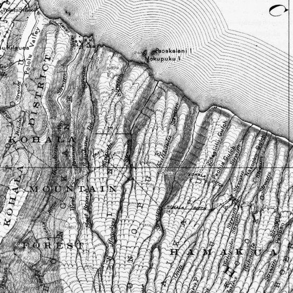
 1916 edition of the usgs map that included the route of both the kohala ditch and the kohala ditch trail Credit: https://on.doi.gov/2MmxVUU |
||
welp... one last ride. just poured myself a tall stiff drink as i'm down to the wire on wrapping up this, the last chapter to this tale [before the ye ole supertopo forum fades into the sunset...]
but before it does, i'd like to say, that i have really appreciated the taco audience over the years. as i'm sure some of you can tell, there have been times that you've effectively been unpaid therapists, as you've held space and bore witness: as raucous as the forum often was, trip reports were almost always a strangely respectful space within the greater forum... so thanks to all, for that.
also, in case this trip report survives as a read only doc and you're coming at this from a google search, the precursors are located here for part one, here for two , here for three and and finally here for part four
all the best folks. hope you all find some of what you're looking for... at the same time that you never completely get there.
alright... here we go... and starting with a final soundtrack:
[Click to View YouTube Video]
The Kohala Ditch Trail: 36ish hrs on foot... to and from the headwaters. [5 of 5]
R. A Tsunami + Jet Planes: devastation of the Waipi'o Valley + another economic revolution for the Hawaiian islands
[1946 + 1959 c.e. or about two generations ago]
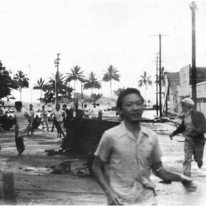 Hilo residents attempting to escape the Aleutian Island generated 1946 tsunami Credit: https://bit.ly/2WF29Xa |
||
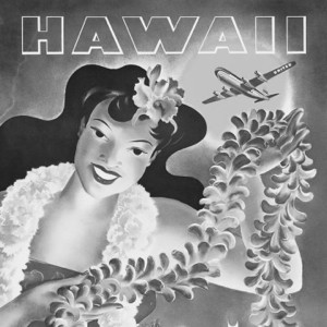 United Airlines tourism advertisement Credit: https://bit.ly/2WD51Ea |
||
1946 Tsunami:
"A mystery surrounding one of the most destructive tsunamis of the 20th Century just got more puzzling as a seafloor search failed to reveal the smoking gun scientists expected to find."
"On April Fools Day in 1946 an earthquake off the coast of the Aleutian Islands in Alaska spawned a series of waves known as a tsunami. One wave as high as a 13-story building hit locally. Others raced across the Pacific, killing dozens and leaving a trail of destruction that stretched to California and even South America."
"The earthquake was too small to spawn the huge local wave, many scientists agree, and they have struggled for decades to figure out what happened. The leading theory has been that the earthquake triggered an underwater landslide, generating a one-two punch."
"But a seafloor-mapping project by Scripps Institution of Oceanography, designed specifically to look for the cause of the tsunami, didn't find evidence to support that theory."
""We found no landslide where there should have been a landslide, where I was positive there had to be a landslide," Gerard Fryer, a geophysics professor at the University of Hawaii, told LiveScience. "I was stunned that there was nothing there.""
www.livescience.com
The Tsunami's Effect on the Waipi'o Valley:
"Kelly Kale Loo, 74, grew up in the valley and still lives close enough that he can walk out the front door of his house and look down on his boyhood home..."
"Loo remembered one Monday morning most vividly. It was April Fool’s Day 1946."
"“I looked back and the tsunami was roaring in,” Loo said. “It swept 1 mile into the valley, then pulled away homes and people when the water rushed back to sea.” At a low-lying spot at nearby Laupahoehoe Point, Loo said, the tsunami smashed into the school, killing 23 children and three teachers. Life in Waipio Valley was largely erased."
"“All gone,” he said. “Sometimes you can see the foundations in the bushes.” Instead of rebuilding, many locals moved to nearby towns, the city of Hilo or the growing resort strip in Kona. By the mid-1960s, the locals were increasingly replaced by hippies who squatted on the land."
denverpost.com
The Beginning of the End for Sugar Production in Hawai'i:
"Sugar plantations suffered from many of the same afflictions that manufacturing market segments in the United States continue to feel. Labor costs increased significantly when Hawaii became a state and workers were no longer effectively indentured servants. The hierarchical caste system plantation managers sought to maintain began to break down, with greater racial integration of the sugarcane plantations. Workers began to discover they had rights, and in 1920 waged the first multi-cultural strike. Global politics played a large role in the downfall of Hawaiian sugar. Shifting political alliances between 1902 and 1930 permitted Cuba to have a larger share of the United States sugar market, holding 45% of the domestic quota while Hawaii, the Philippines, and Puerto Rico shared 25%."
"The Big Five slowed the production of sugar as cheaper labor was found in India, South America and the Caribbean and concentrated their efforts on the imposition of a tourism-based society. Former plantation land was used by the conglomerates to build hotels and develop this tourist-based economy which has dominated the past 50 years of Hawaiian economics."
en.wikipedia.org
And the Beginning of the Start for the Hawaiian Tourism Industry:
"It's no coincidence that Hawaii -- the most isolated landmass in the world -- experienced a boom in tourism at the same time that jet travel became accessible. Pan Am's 1959 introduction of Boeing 707 jet service to the islands opened the flood gates and soon more people were traveling to the islands more often."
"Airlines promptly set about wooing passengers, encouraging them to travel to places like Hawaii. One vintage United Airlines advertisement describes Hawaii as "painted in every hue of the rainbow, flavored to every taste, guaranteed to relax. All you need to do is choose your island," it declares. "The aloha spirit will do the rest.""
huffpost.com
finally: back to pololū
[19:00ish : 17.06.2018 : km 38ish : ~4350m gained
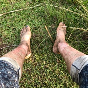 back at pololu: tromping in the bush is neither good for the skin nor the pedicure... Credit: nah000 |
||
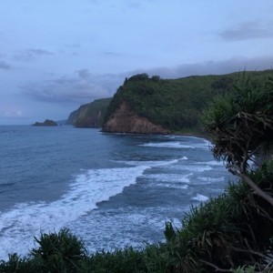 one last look back towards where i'd just spent the last 36ish hours. Credit: nah000 |
||
while it might seem like the decaying pants that i left you with, at the end of our last juncture, were just a cheap literary trick, in that moment it really did feel a bit more ominous than i wanted to admit... the repeated up and down over the valley's edge, with no success at getting back through to a trail, was starting to get very old... and disconcerting.
on the up side, there were no further signs of a mr/s. nopantswo/man.
after exhausting all conceivable options on finding where the trail had met the top of the valley, i finally resigned myself to dropping straight back down to the bottom of the valley in the hopes of once again crossing the trail. given the gps locates i had and where i had dropped in the last time, the only thing that made sense was to drop in about a 100m or so further up the ridge...
if i went straight down this time i'd have to cross the traversing trail... right?
well, that was the plan and with the other obvious options exhausted, there was seemingly only one thing left to do...
and so i dropped back in.
and once again thrashed through the jungly underbrush, basically repeatedly falling down the steep slope in order to flatten the fronds that covered that area so that i could move down.
as i neared the bottom and with complete disbelief, i once again found myself in the position where I still had not found the trail. with no choice but to continue putting one foot in front of the other i did one more tree rappel descent onto a ledge...
and when i landed i burst out laughing.
literally about five feet above the valley bottom i had hit the trail.
sweet baby jesus... what a relief.
while there is more i could tell, this is where we get to the blah, blah, blah of this report: over the next half a dozen or so hours i reversed my path back to the pololū valley...
good part was i managed for the first time, on these excursions, to stay on the trail the entire way.
and the bad part was i was so exhausted from the long miles, the jungle thrashing, and the monotononous [at this point] up and down, that i wished i'd brought a hard hat as i kept repeatedly bashing my head into low hanging branches...
ultimately all that matters to the telling of this tale... is that i made it back.
S. Castle and Cook + John Hall and the gang: the last sugar harvest + the first written account of an overland north slope traverse from Pololū to Waipi'o
[1975 + 1977 c.e. or about one generation ago]
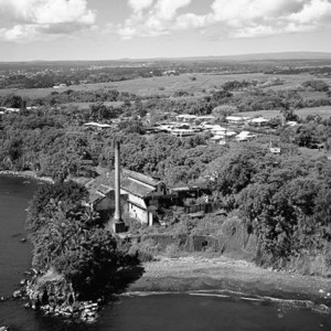 a decaying sugar mill on the hamakua coast [and yes: i paid for the rights to use this photo here] Credit: https://bit.ly/2XlZMG2 |
||
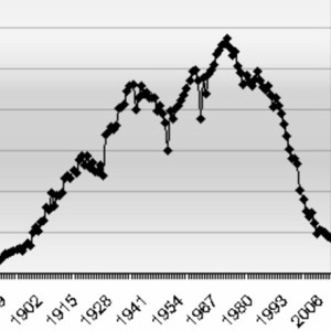 Hawaiian sugar production in tons from the early 1900s to the early 2000s Credit: https://bit.ly/2wwEDgp |
||
The Last Sugar on the Big Island:
"Prosperity came to Kohala. At the peak of its production, the Sugar Company counted 600 employees, 13,000 acres of land, and produced 45,000 tons of raw sugar a year. The five sugar mills, which consolidated in 1937, generated their own electricity. There was a single telephone line along the ditch trail, to enable necessary communication. The isolated farms, because of the never-ceasing flow of water, even used conventional toilets. A railway steam-train hauled the cane to the Mahukona harbor."
"But then the inevitable news came: in 1971 Castle & Cooke announced the closure of the Sugar Company. Over 500 employees were threatened with immediate unemployment. Most of them had no other education than the intricate cultivation of sugar cane. With a small population of 3000, Kohala's reason for existence had ceased to be, and the quaint towns of Hawi and Kapaau, were threatened to become ghost towns with a forgotten past. In 1975 the last sugar was harvested."
coffeetimes.com
The first written account of an overland north slope of the Kohala traverse from Pololū to Waipi'o:
"It was August of 1977 when Fred Dodge and his two teen-age children, Charlie, 17, and Alyce (Tootsie), 16, and I hiked across the north slope of the Kohala mountain from the end of the road above Pololu Valley to Waipio Valley. I had hiked the Kohala Ditch trail with the Hawaiian Trail and Mountain Club some years before on a trip organized by Dick Booth, I believe. On that trip we had taken the inland trail, and wound behind a waterfall and in and out of many deep gulches before reaching the end of the trail. This time we stayed on the coastal route, crossing the mouth of Pololu Valley and climbing the wall on the farside. Here the trail forks, with the right branch running up the ridge and eventually connecting with the inland trail in Honokane Nui Valley. "
"We intended to take the left fork, but it crossed a patch of bare dirt at the junction and was less obvious, so we missed it and hiked some distance up the ridge before realizing our mistake. This is standard procedure for a Dodge-Hall hike. Each of us suffers from the misguided notion that the other one is paying attention and will keep us on the trail! Eventually, we found the right trail, however, and followed it down and across the mouth of Honokane Nui and over the next ridge to a small but lovely campsite near Bill Sproat's cabin in Honokane Iki. There is a small, but secluded bay at the mouth of Honokane Iki, and I slung my hammock between two trees at the head of this bay, while Fred and his youngsters put up their tent on a flat nearby. Cliffs lined thesides of the little inlet and coconut palms graced the shore at thehead. In all, it would be hard to find a more beautiful and tranquil camping spot."
"According to my old topo map, the Kohala Ditch Trail ends at Waikaloa Stream, but I am not sure we actually got that far. Certainly there was no major stream where we finally lost the trail. A straight line route, as the crow flies, from the end of the trail at Waikaloa Stream to the near side wall of Waimanu Valley is less than two and a half miles long. It was to take us 3 days of hard, wet, miserable, hiking to get there. We were caught in a major storm. The rain never let up for the next 3 days, but maintained a steady, drenching drizzle, quite often with bursts of heavier rain. I had lined my pack with plastic bags, but after this trip I put grommets in the bottom of each compartment to serve as drain holes, as I found that the fabric, while not exactly waterproof, would (and did) hold about an inch of water in each pouch, so that it had every opportunity to find any pin-hole leak in the plastic bags. Fortunately, my sleeping bag and matches stayed reasonably dry. Fred and the kids were not so lucky. They slept in wet sleeping bags."
extremehikinghawaii.blogspot.com
klink came back: edmonton, ab
[13:00ish : 30.06.2018]
 note to self: cat's are only ever partially domesticated. Credit: nah000 |
||
 also, while i'm not a cat psychologist: if that's not the look of a depressed cat i'm not sure what is. for at least a couple weeks after her return, klink had this look and temperament. Credit: nah000 |
||
remember, from part one, those posters my sister had put up for the missing cats? because here's where that portion of the tale finally becomes relevant again.
that's because about a week after i got home, my sister got a call from a neighbor who lived only a street away, and who thought they might be seeing the grey and white kitty who was on the posters she'd put out...
i didn't want to get my hopes up, but i also had to see for myself, so the first chance i had to make the three hour drive, i headed to my sister's place to see if i could find my cat.
and sure enough. within a half hour of going over to the neighbor's house i saw klink.
i tried to approach her, but there was no chance. after threeish weeks on the lam she was feral as feral could be and so had no interest in letting me get anywhere near to her.
i tried a few different things, but ultimately as i was getting ready to set up a sort of "trap" she got close enough to the food that i had set out that i could basically touch her.
so i did...
and not just touched, but grabbed...
big. fUcking. mistake.
lesson learned: if you're going to wrangle cats, you best wear gloves.
i wasn't and i immediately had a blood gushing, golf ball sized knuckle where she had chomped into me.
but i held on and got her into the cat carrier as she continued to scratch, claw and bite.
still, about five minutes later i was petting her as i drove away [to get my tetanus shot updated and to be put on a course of penicillin... ha!]
T. Apology Resolution + Another Earthquake: an unresolution + major destruction along the Kohala Ditch Trail
[1993 + 2006 c.e. or about half a generation ago]
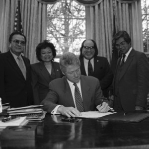 bill clinton signing the apology resolution Credit: https://bit.ly/2WJAW61 |
||
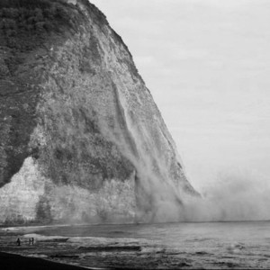 a portion of a cliff near to waipi'o dropping into the sea Credit: https://bit.ly/2IheAzc |
||
The Apology Resolution:
“United States Public Law 103-150, informally known as the Apology Resolution, is a Joint Resolution of the U.S. Congress adopted in 1993 that "acknowledges that the overthrow of the Kingdom of Hawaii occurred with the active participation of agents and citizens of the United States and further acknowledges that the Native Hawaiian people never directly relinquished to the United States their claims to their inherent sovereignty as a people over their national lands, either through the Kingdom of Hawaii or through a plebiscite or referendum" (U.S. Public Law 103-150 (107 Stat. 1510)). The resolution has been cited as a major impetus for the Hawaiian sovereignty movement, and has been the subject of intense debate.”
“Although the histories of Native Hawaiians and Native Americans are significantly different, there is still a widely held perception that Native Hawaiians have received similar kinds of unfair treatment from the U.S. Government as Native Americans. The Apology Bill is thus seen as a means of acknowledging historical grievances that they believe are valid. Some also see it as a step towards identifying Native Hawaiians as an indigenous people to preserve for them specific legal rights based on ancestry; some also see it as the beginning of a process to provide compensation or reparation to native Hawaiians for alleged past injustices.”
"How this decision on the "nonsubstantive" nature of the Apology Resolution will affect the pursuit of the Akaka Bill, which has based itself on the Apology Resolution, is not yet clear."
"In 2009, the U.S. Congress passed a similar resolution, S.J.Res. 14, "To acknowledge a long history of official depredations and ill-conceived policies by the Federal Government regarding Indian tribes and offer an apology to all Native Peoples on behalf of the United States.""
en.wikipedia.org
Another Earthquake:
“Early on the morning of October 15, 2006, two moderate earthquakes—the largest in decades—struck the Island of Hawai‘i. The first of these, which occurred at 7:07 a.m., HST (1707 UTC), was a magnitude (M)6.7 earthquake, centered beneath Kïholo Bay on the northwestern coast of the island (19.878°N, 155.935°W), at a depth of 39 km. The second earthquake, which struck 6 minutes, 24 seconds later, at 7:14 a.m., HST (1714 UTC), was located 28 km to the northnorthwest of Kïholo Bay (20.129°N, 155.983°W), centered at a depth of 19 km. This M6.0 earthquake has since been referred to as the Mähukona earthquake. Losses from the combined effects of these earthquakes are estimated to be $200 million—the most costly events, by far, in Hawai‘i’s earthquake history.”
pubs.usgs.gov
And its damage to the Kohala Ditch and its Trail:
"The privately owned Kohala Ditch was seriously damaged in the quake and, as a result, the water stopped flowing. Built in 1905 and 1906 by 600 laborers, almost all of them Japanese, the ditch is widely considered an engineering marvel. Seventeen men died during its 18 months of construction, which was authorized by an Act of Congress. Pre-earthquake, the 100-year-old ditch carried up to 12 million gallons of water per day along its 14.5-mile route, transporting water to many farmers and other users from Honokane Stream west to Hikapoloa, near Hawi. When that stopped flowing, many Kohala farmers and ranchers were suddenly and critically without the water they needed to run their operations."
"The ditch's owner, Surety Kohala Corp., could not afford the enormous repair costs, and yet the ditch had been supplying water to many Kohala agricultural businesses and operating as a much-needed public utility, explains Rory Flynn, a member of the post-quake-organized Kohala Ditch Restoration and Preservation Project. The community-based group of eight members met every week or two for months in order to raise the $3.5 million needed to restore the ditch."
"Ed Boteilho is the owner of Cloverleaf Dairy in Hawi, which used to be one of the ditch's biggest users. His dairy operation, consisting of 1,500 cows and 1,033 acres, is one of only two on the island and produces most of the Big Island's milk-3,400 gallons per day. "
""We depend on the ditch for irrigation," he says. "It's our lifeblood." Without the water to irrigate his acreage, Boteilho says, he has had to purchase feed for his animals, driving up his costs."
""All I had to service 1,500 animals was a one-inch water line from the county," he says. "I put in new water lines, six pipes, to connect to the county water, and started hauling water. I tried to haul about 60,000 gallons a day just to keep my farm going. Some days I couldn't. Some days I could only haul 20,000 gallons.""
"As a member of the Kohala Ditch Restoration group, Boteilho says he has testified before the Legislature many times. "We're working to make the Kohala Ditch self-sustainable.""
"The group has raised the entire amount needed for repairs, with funds and other help coming from the federal, state and county governments, Kamehameha Schools, on whose land the ditch starts, the AT&T Foundation and private sources."
honolulumagazine.com
the mookie [and six more cats] came back: edmonton, ab
[19:00ish : 26.01.2019]
 one big cat skeleton: and six smaller ones Credit: nah000 |
||
 a proud mama Credit: nah000 |
||
while i kept looking on the edmonton pound's site... and quickly learned that all black cats look very similar in photos... i basically gave up hope that mookie would ever come back... i even went so far to adopt another friend for klink [a stray tuxedo cat who showed up at one of my construction sites...]
but this tale wouldn't be complete with what you now already know.
six months later, i got a text from the same people who had seen klnk: they thought they were seeing a black cat similar to the description and photo that had been on the poster and that i'd told them about when i was able to get klink back.
so once again i headed to edmonton.
this time, while mookie was also just as scared as klink had been, the neighbors had managed to inadvertently trap mookie in their house. and so given some time she actually seemed to remember who i was and tentatively let me pet her as she had not allowed anyone else to do.
and the kicker?
a couple weeks later as she rapidly fattened and I took her to the vet, i found out some more news: she was pregnant.
in short, over the course of one year i went from two cats, to zero cats, to one cat, then two,, and then finally a few weeks after mookie had come back... there were nine fUcking cats in my house.
and i loved all of them... :)
U. Current Land Ownership: residue of generations old histories
[2019 c.e.]
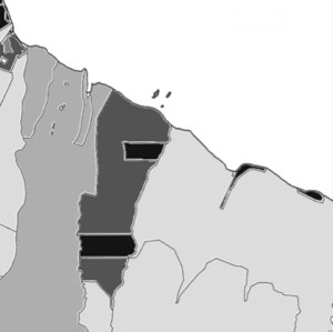 white = ocean; light grey = state owned land; medium grey = bishop estates; charcoal = surety kohala corporation; black = assorted private land owners Credit: nah000 |
||
 1916 edition of the usgs map that included the route of both the kohala ditch and the kohala ditch trail Credit: https://on.doi.gov/2MmxVUU |
||
what has all of the history that has been recounted over the last few pages left us with?
there are basically three land owners who currently own the land that the Kohala Ditch Trail is on:
~50% of the trail crosses state land with most of that being the kohala forest reserve... this was almost all of the land that i covered from the honoke'ā valley on.
~30% is owned by the bishop estates which provides funding to the Kamehameha Schools [and whose land ownership goes back to the great Mahele land division]
~20% is on land that is owned by the Surety Kohala Corporation [which was formerly called the Chalon Corporation] which at the time of purchase was a Japanese corporation that purchased most of the sugar cane owned acreage in the northern kohala.
and finally <5% was owned by individual stake holders [including a descendant of Bill Sproat and both other local and u.s. continental based owners]
County of Hawai'i Real Property Land Reports
why i believe in a north american allemansrätten: calgary, ab
[01:00ish : 01.06.2019]
 mookie. Credit: nah000 |
||
 klnk. Credit: nah000 |
||
hopefully, with these serial reports, i’ve laid out some of where my now strongly held belief in a north american right to roam, has come from. and so if you haven't heard of allemansrätten, give it a quick google... i think it will be worth your while.
ultimately, the short of it is, by the current law of the land, here in both the u.s. and canada, what i did on this adventure was, shall we say, inadvisable.
and so while i didn't go out on this adventure with the intent to come to justify the following opinion, still here we are: that in north america the exception to the rule is that a human can sleep on and cross over land only with the permission of another human is, imo, madness.
hopefully someday we come to our collective senses and realize that exactly the opposite should be the case: in general [and accepting certain constraints regarding privacy, the respect of cash crops and duration of stay: all of which our swedish cousins have seemingly worked out] no one should have to ask permission or pay to either lay down their head to sleep on, or to move over, earthen land... that no human had a hand in creating.
while i had no intentions of this being my last trip report... sometimes life throws you a curveball. and so while i didn’t have a chance to flesh this final portion out as much as i intended, still hopefully this was worth your while. if there are mistakes please contact me at nah000 at hotmail dot com. admittedly it will likely just be for my own edification as with the death of the supertopo forum i don’t know how long i will be able to edit the content.
all the best all.