Trip Report
Mt. Humphreys Northwest Arete - Labor Day
Thursday September 4, 2014 12:11am
top left corner top right corner
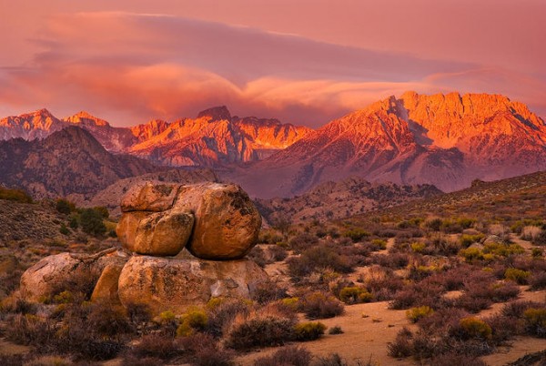
Humphries East Arete; "Magic McGee"; Mt. Locke; and cirque
Credit: KabalaArch
bottom left corner bottom right corner
We – my daughter, son in-law, and selfie – have made 2 attempts on the “Classic” (read: crowded) East Arete.

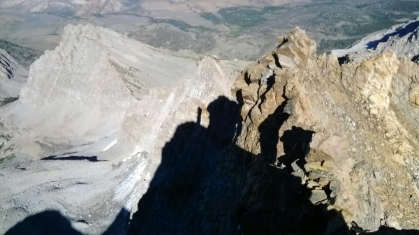
And each attempt has ended identically, in unmeasured failure, pathetic retreat, and abysmal shame. This being a signature characteristic of this otherwise classic route, we've maintained our batting averages by avoiding this route closely. Next season, we plan to avoid this ordeal once again, to preserve our record for the most failures on the East Arete route.

top left corner top right corner
Mt.Humphries West Face
Credit: KabalaArch
bottom left corner bottom right corner
In order to train for the East Arete, we've taken to the Northwest Arete, mostly for the exercise and fresh air. This photograph shows the SW aspect of the mountain as seen from “Camp 509.”

The fastest and least exhausting line of approach wants, I think, to follow the contact zone between the buff-colored granite of the upper 1/3 of the mountain's mass, and the dioritic plinth, deeply raked with steep narrow clefts and chutes, on which the summit formation bears.

top left corner top right corner
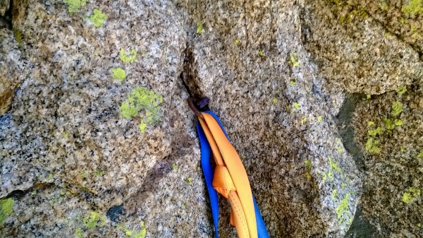
Ring angle belay/rap anchor
Credit: KabalaArch
bottom left corner bottom right corner
Top of the Trough, start of the traverse out and onto the Arete.

top left corner top right corner
Northwest Arete belay ledge.
Credit: KabalaArch
bottom left corner bottom right corner
Marmot Lake.

top left corner top right corner
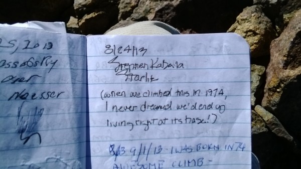
August 24 2013 summit Register entry by SWIM.
Credit: KabalaArch
bottom left corner bottom right corner
Note the Register entry below my own. It's kind of cool to carry a conversation along in the pages of the summit Registers...later, if you happen to know the climber you can walk up and ask him (or her) about their experience on Mt. Saint So and So.

top left corner top right corner
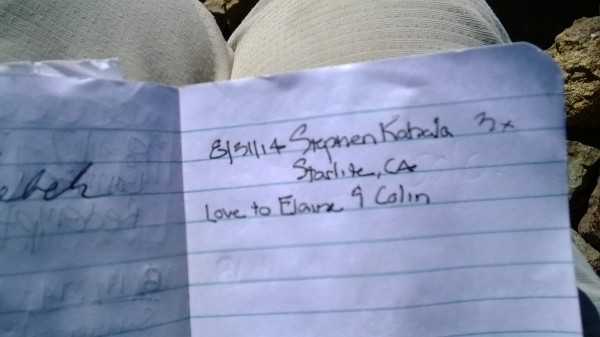
August 31, 2014 summit Register entry, by SWIM
Credit: KabalaArch
bottom left corner bottom right corner

top left corner top right corner
Desolation Lake
Desolation Lake
Credit: KabalaArch
bottom left corner bottom right corner
Merriam; Royce; Feather (with Seven Gables on the horizon beyond); Hilgard; Julius Ceasar; Bear Creek Spire South Face; Four Gables.

The ridge connecting Four Gables to West Basin Mtn (next slide) is an excellent skywalk; largely level, and above 13,000'. The descent gully into the Upper Horton Lakes cirque cliffs out into 4th, heads up and maybe find a better descent.

top left corner top right corner
Credit: KabalaArch
bottom left corner bottom right corner
Broken Finger; Adamson Mine; Mt. Wheeler; Round Valley Pk – are West Basin and Basin Mtn in the foreground with unidentified metamorphic pyramid hulking between and beyond them.

top left corner top right corner
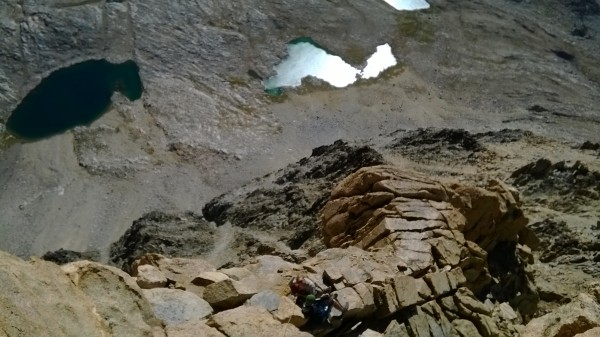
"Magic McGee"/East Arete
Credit: KabalaArch
bottom left corner bottom right corner
Lots of people get shut down at that East Arete satellite summit. Basically, the shortest straw gets you either the loose downclimb, or a snafu-prone rappel into the notch. Either way, it looks to be about 200 feet. There's enough foot traffic (is there any other kind up there?) to have formed a good use trail into the Clyde Route's South Gulley up to this same East Notch, and so when I fail to give the East Arete a try next season, it shall be via this approach.

There are a couple of climbers descending the upper East Arete in the photo. They're moving very slo o o w ly, which is probably why you can't see the guy in blue nor his partner in red and out on point. But what can you expect from a Telephone-Camera-GPS-Personal Mgr-internet browser? So convenient – I'm actually posting this trip report as we descend the West Ramp into Camp 509!

top left corner top right corner
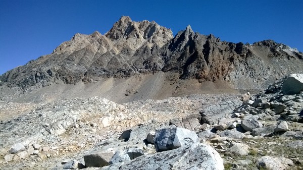
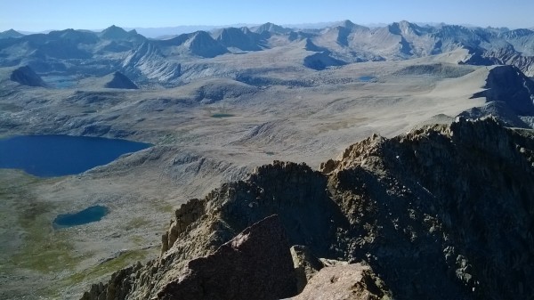
Humphries Basin - south
Credit: KabalaArch
bottom left corner bottom right corner
This might be one of the most intriguing reaches of the Crest, an alpine Bermuda Triangle which has captured my imagination and held it at Swiss Army Knife-point since the late 1990's.

As is plainly shown, the slabs and the meadows of Humphreys Basin slope gently to meet the Crest ridge. Then, in a hair's breadth, the floor drops out – 2,500' – 3,000', instanter!, with this prominence then increasing quickly as would be expected from a thrust-block mountain range.

Once upon a time, a Civil Air Patrol rescue mission, based out of Fresno County, was recalled, according to our local newspaper, and an Inyo County air extraction team dispatched in its place. The confirmation of fatalities had eliminated the need for an urgent rescue response, and this response I interpreted to mean only one thing.

The vicinity where the missing aircraft's emergency transmitter had gone down, which here shows as the uppermost lakes in Humphreys Basin, is not in Fresno County but in Inyo County. This distinction becomes essential when the First Responders seek cost reimbursement from the jurisdiction’s funding agencies.

These lakes are not within the hydrology of Humphreys Basin at all. They drain southeasterly into Paiute Creek, thence Owens River, even as these headwater lakes appear to be ensconced at a somewhat higher elevation than their neighboring lakes in the Basin drainage proper. This also means that no part of Checkered Demon, Mt. Emerson, or their interconnecting ridges, occupy the Crest - they're outset.

A quick armchair examination of the USGS topo quads will corroborate the true hydrological divide of the Paiute Pass vicinity. It was much more engaging, though, to field verify the existence of a white area on local maps and lore, a sort of “Bermuda Triangle” close at hand. Setting action to words garnered the 2nd ascent of one of Mt. Emerson’s northwest satellite towers, in about 2002. Some of Mt. Emerson's satellite towers and outliers had been identified as prospective climbing objectives in the 1954 through the 1963 Hervy Voge "High Sierra Climbing Guide" editions. Perhaps this tower was one of these problems?
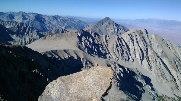
top left corner top right corner
Credit: KabalaArch
bottom left corner bottom right corner
One of the lakes down there is good old Camp 509. In fact, it's pretty easy to identify from an aerial perspective.

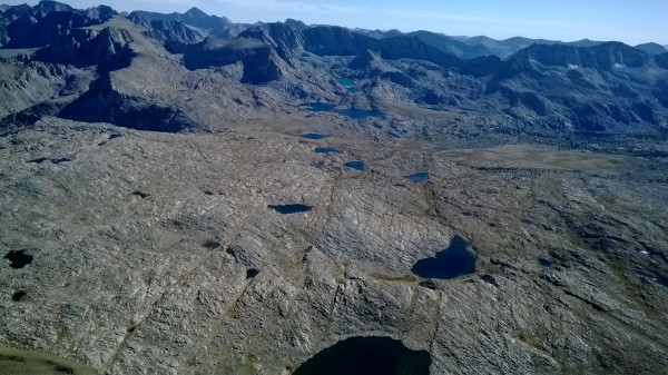
It's not until you're back on the ground that the full scale of the labyrinth becomes apparent. Each lake, or tarn, is ensconced in a miniature basin-and-range drainage pattern all its own. The lakes might be quite close to one another, but lie at differing mean elevations within separate micro drainage basins, with no interconnecting streams between adjacent lakes or master watercourses. These lakes are situated in bowls which may have a relative depth of bout 100 feet.

Each lake, and its watershed, presents as a stereo-isomer of each its neighbors, greatly complicating cross country travel navigation.

All of this means that you can't see from the depth of one bowl into another, and, from the tops of the ridgebacks which form the localized watershed boundaries, there's little line of sight communication possible between bowls.
So the only way to check your bearings with any degree of precision is to ascend about 100 feet from the talus shore of the one tarn, and then descend about 75 feet to the shoreline of the next tarn, to find it very analogous in appearance to the tarn you've just traversed.


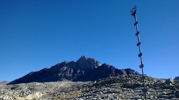
The relative success of the snowpack survey stake #509 in helping confirm the identity of the proper Base Camp lake depends, of course, upon travel during daylight hours. August 2013 would have gone better had I troubled myself to set down the coffee 30 minutes earlier that morning.

"An hour in the morning is worth 3 in the afternoon" goes the old expression - I've recently acquired the habit of inventing 'Old Expressions,' and the source of that one is probably the guy who also claims that "1 mile of cross country is worth 5 miles of trail."

Noted that such pearls are irrelevant to a team up to climb say, something on the Apron, or similar projects which make up in technical difficulty what they lack in way of a true summit.

In this instance retreat is effected by rappel, and the summit is simply a matter of choosing the optimum ledge to represent the day's high point. Headlamps are useful at dusk, when a field of vision which only needs to include hardware and some sense of direction towards your car.

When the day's objective is not your car, in a roadhead parking lot, but a small dark pack next to 1 of 10 identical small black lakes, and the means to get there safely involves more gravel than trail, a grasp of a consensual reality is all that's necessary to understand which creature comforts may be sacrificed in order to survive the day and see another.

And while a headlamp can illuminate trail-less sand and gravels at foot level, it's a puny defense against all the man trap potholes, caves, and sudden cliffs which landscape this alpine Bermuda Triangle. At this point, a broken ankle, or worse, is less a possibility and more a statistical probability. And so this night was spent out in the open, an unplanned shelterless bivouac above 12,000'.

As a first time experience, it wasn't too bad. This year, though, would have made 3 climbers miserable instead of just 1, and since one of these persons would be my very own daughter, it wasn't happening.

And all that was needed this year was a slightly earlier start, a light hearted but pointed morning motivational talk, and a consistent cadence throughout the day:

"Slow and Steady wins the Race."

top left corner top right corner
Back in Camp!
Back in Camp!
Credit: KabalaArch
bottom left corner bottom right corner


All of our cameras were too crude to capture the Coast Range mountains distant but visible way out west. Like Mammoth Mtn, there are few obstacles to the Pacific storm track, so if it's snowing anywhere in the Central Sierra other than Mammoth, its going to be dumping into the Humphreys east cirque, perpetuating a cycle of glacial quarrying; strong wind rotors to precipitate greater snowfall yields, etc.


  Trip Report Views: 3,296
KabalaArch
About the Author
KabalaArch is a trad climber from Starlite, California.

Comments
Sierra Ledge Rat

Mountain climber
Old and Broken Down in Appalachia
  Sep 4, 2014 - 12:46pm PT
Looks like you have some terrible weather.....
Bob Harrington

climber
Bishop, California
  Sep 5, 2014 - 09:16pm PT
I like your style, kabala
rottingjohnny

Sport climber
Sands Motel , Las Vegas
  Sep 5, 2014 - 09:21pm PT
She's so fine my 509...
franky

Trad climber
Madison, WI
  Sep 5, 2014 - 09:53pm PT
I guess someone bootied the solid nut Inyo SAR left to backup that piton a few years ago. I was impressed with the amount of tat that people tie that single piton up with, as if the webbing is the weak link, not the single soft-steel piton that has been through thousands of freeze-thaw cycles without a single hammer blow.
mouse from merced

Trad climber
The finger of fate, my friends, is fickle.
  Sep 5, 2014 - 10:00pm PT
That Humphreys Basin shot gives me the willies, thinking of the huge ice masses covering that place in the olden days.

I like the way you carry on a summit register conversation, too. That is, like, "unheard of & sh!t."
JEleazarian

Trad climber
Fresno CA
  Sep 5, 2014 - 11:30pm PT
Neat TR of a beautiful mountain. Thanks much.

John
KabalaArch

Trad climber
Starlite, California
Author's Reply  Sep 6, 2014 - 12:38am PT
More flights of fancy are possible on the east side of the “Crest,” the South Fork of McGee Ck, than the west, Mr. Mouse.

Rather than ask our gentle readers to indulge a wall of text tonight, I'll try and limit my armchair geomorphology to just the glaciation picture as I read it.

The summit of the East Arete satellite is about 13,182' or so, Humphreys tops out at 13,986', representing a differential of roughly 900' (a rude wake up call when your stranded on the gendarme, and the sun's getting low).

During one or another successful gendarme conquest, I noticed some well preserved and plentiful patches of glacier polish. “Odd,” I remarked to one of my multiple personalities, “to encounter so much so high...”

Moreover, I recalled reading Agassiz or peer as setting forth the minimum thickness of ice necessary to compress and polish granite as about 300'. Subtracting this minimum depth from our 900' differential yields 600', which, by line of sight, appeared to correspond, roughly, to the maximum elevation of glaciation sign on Humphreys summit block, give or take. Higher were frost fractured granite blocks, and the sands of time, of relatively recent formation, maybe some minor deposition, but for practical purposes lacking in residual glacier signature.

Meanwhile, the floor, and the drainage outflow of the cirque show textbook lateral moraines, and while definitive terminal moraines have been largely carved away by water action, the sequence of recessional terminal moraines hard beneath Kindergarten and Checkered Demon Couloirs look freshly mined, probably because they were formed during the Little Ice Age, my guess.

Off in the distance, we can see the lateral moraine on the north side of Bishop Ck, and the striation of the granite bluffs on its south side, upstream of Little Egypt. These continue down to an elevation of roughly 5,700' or so, and would have confined your typical montagne glacier.

So...to the extent that the polish defines the glacier high water mark (or some 300' beneath it), the toe of the lateral moraines indicated the terminus, we can form an approximate image of the glacier at its maximum. To remember that the prominence of the Crest above the cirque floor is some 2,500' at its headwall, and increases steadily but rapidly downstream, is to conjure an image of an extremely thick, dense, yet oddly truncated ice cap-like formation, hugging and concealing the range this region before precipitously dropping off into the unslakable thirst of the desert.

This image was to be refined and reinforced during an (awful!) ascent of Paiute Crag 7.

There, the only really viable lines of approach are up the intervening chutes. The floor of these are cobbled with a talus of small, large, very large river rock, rocks which had clearly been river run for many thousands of thousands of years in the subglacial melt waters. The topmost extent of these cobbles was within just a few hundred vertical of the ridgecrest (so much choss; I believe that's where they make it). Metamorphic, any other sign of glaciation has long since eroded away from the record.

Unanswered is the question: if a 300' minimum depth is required to result in polished granite, what ice depth is necessary to produce enough meltwater to cobble river rock?

I had to leave a #2.5 Camelot (my favorite one!) up there fixed, since I found a better descent...so booty to the one who goes up for peer review!
mouse from merced

Trad climber
The finger of fate, my friends, is fickle.
  Sep 6, 2014 - 04:09am PT
Yeah, I'm not up for a wall, either; so that "crag" of a limited discussion of the area's glaciology is more what's called for.

Y'all are a trained observer, Doc.

Till later--and thanks for letting us audit your class.
Ezra Ellis

Trad climber
North wet, and Da souf
  Sep 6, 2014 - 08:48am PT
Nice job!!!
le_bruce

climber
Oakland, CA
  Sep 10, 2014 - 03:12pm PT
Top shelf TR - thank you.
KabalaArch

Trad climber
Starlite, California
Author's Reply  Sep 29, 2014 - 10:54pm PT
Sorry about the loquacious Cliff Notes as to the hypothetical glaciation of the “South Fork of McGee Creek” cirque. I understand that my picture of what might have been has not been met with universal accord, but it was painted in pretty broad strokes.

However, the glacier polish I mentioned does indeed exist up top the gendarme; I've witnesses and, of course, everyone's welcome to field verify for themselves.

But here's another observation which may create serious controversy:

Every time I head up into this cirque, I can't help but notice that the approach roads do not cross any streambeds nor watercourses south of that uppermost McGee Creek ford.

Google sat images show a narrow strip of aspens which appear to cross over the benchland at about 8,500'. Since the USGS quad is based on aerials, it's based on the same or similar data as the Google imaging. But careful field observation confirms an unbreached hydrological divide which descends from “Magic McGee” all the way down to Grouse Mtn.

This would seem to indicate that the “South Fork of McGee Creek” is actually the North Fork of Birch Creek.

But what's the likelyhood that there still might be blank areas on a map of country in full sight of Bishop?
justthemaid

climber
Jim Henson's Basement
  Sep 30, 2014 - 07:36am PT
bump
PellucidWombat

Mountain climber
Draperderr, by Bangerter, Utah
  Oct 2, 2014 - 08:21am PT
Haha, I can see what you mean about that basin. When I went over in winter, I was possibly going to meet up with some friends coming from another direction . . . a bit tough to know if you missed them!

Reminds me of Dusy Basin as well. I came back in the dark once there, couldn't find the tent & had to bivy. When the sun came up, my tent was only 100 ft away - blending into the boulders! We must have walked by it several times in the dark. GPS to mark the campsite is helpful in those situations ...
le_bruce

climber
Oakland, CA
  Aug 13, 2015 - 10:09am PT
RIP KabalaArch. Always appreciated his contributions and positivity here, always got the distinct sense that his mind and its reaches were vast.
guyman

Social climber
Moorpark, CA.
  Aug 13, 2015 - 11:02am PT
RIP..... your words will live on.

Go