Northwest Buttress, Tenaya Peak 5.5 |
||
Tuolumne Meadows, California USA | ||
|
Google Maps Overview
|
|
|
The GPS coordinates for this route are shown below. See the GPS Marker Legend at right for details on each marker. Click on the Marker to see the actual GPS coordinates. Approach
Park at the large parking lot with bathrooms, about 300 yards northeast of Tenaya Lake. Hike straight across the woods and meadows, aiming for the toe of the buttress. Work up surprisingly good deer trails to the left, then scramble and bushwack a bit to reach the toe of the rock. If you get on the main lower ledge, a short polished scramble leads up a waterchute, or simply work back left and go up and around. In general, the scrambling is easier than it looks. Look for trails and paths around difficulties.Descent
Hike west down the ridge from the summit, generally staying to the left side of the actual ridgetop. After about 0.5 miles, start looking for an open bouldery area about 200 yards below some large rock formations on the ridgetop. Work around to the right and join the main ledge system. It helps to have carefully eyed the ledge system from the car ahead of time. There are some hard climbs on steep cliffs above the ledge once you start down. Follow the ledge all the way back (but be very careful, its easy to get on dirty steep slabs). Once back at the start of the ledge, descend back down where you came up (or thrash down almost anywhere).An easier, but longer, alternative is to keep hiking down the ridge until you reach a major hiking trail, then follow this back to the right. When the trail splits, the left branch leads to the road at the Sunrise trailhead at the west end of the lake, and the right contours along the lake back to the beach. This latter trail is very beautiful, with perfect views of the lake and Stately Pleasure Dome on the far side. |
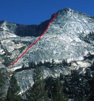 Photo: Greg Barnes
|
Home | Climbing Areas | Free
Topos | Guidebooks | Route
Beta | Forum | Trip Reports |
Photos | Articles
Links | Terms | Privacy | FAQ | Contact
| About Us
Climbing Areas
Rock Climbing Yosemite |
Big Wall Rock Climbing Yosemite |
Rock Climbing Tuolumne |
Rock Climbing Sierra
Rock Climbing Red Rocks |
Rock Climbing Southwest |
Rock Climbing Zion |
Rock Climbing Tahoe |
Climbing Alaska
All trademarks property of their respective owners
How can we improve SuperTopo? Got feedback?
![]() Let us know!
Let us know!
Climbing is dangerous. Climb at your own risk.