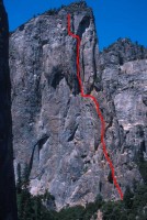
Northeast Buttress, Higher Cathedral 5.9 |
||
Yosemite Valley, California USA | ||
| ||
|
Google Maps Overview
|
|
|
The GPS coordinates for this route are shown below. See the GPS Marker Legend at right for details on each marker. Click on the Marker to see the actual GPS coordinates. Approach
If driving from Camp 4: take Northside Drive to El Capitan Meadow. Turn left at the triangle and drive east to just before you meet Southside Drive (the one way road). Park on the side of the road and walk 300 feet west on Southside drive to the pullout on the left (south). If driving into Yosemite Valley: on Southside Drive, park 300 feet before the turnoff to El Capitan Meadow at the paved pullout on the right. From the middle of the pullout, walk 300 feet, passing a climbers’ information sign, to the Valley Loop Trail. Turn left (east) and walk 300 feet until a climbers’ trail is visible on the right. Follow this trail for... GET Yosemite Valley Free Climbs and read the rest this approach as well beta for over 200 other classic Yosemite routes. Descent
From the last pitch, hike south and west toward the summit. From near the high summit, walk south and down the ridgetop through brush and sandy ledges to the main notch between Higher Cathedral Rock and the valley wall. Follow the well-traveled climbers’ trail as it switchbacks down through trees and brush onto talus. Hike down the talus until you meet the approach trail.
|
Home | Climbing Areas | Free
Topos | Guidebooks | Route
Beta | Forum | Trip Reports |
Photos | Articles
Links | Terms | Privacy | FAQ | Contact
| About Us
Climbing Areas
Rock Climbing Yosemite |
Big Wall Rock Climbing Yosemite |
Rock Climbing Tuolumne |
Rock Climbing Sierra
Rock Climbing Red Rocks |
Rock Climbing Southwest |
Rock Climbing Zion |
Rock Climbing Tahoe |
Climbing Alaska
All trademarks property of their respective owners
How can we improve SuperTopo? Got feedback?
![]() Let us know!
Let us know!
Climbing is dangerous. Climb at your own risk.
